Update February 27, 2026
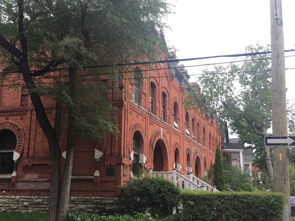
The Church on 325 Elgin is part of the Minto Park Heritage Conservation District under By-law 142-88, originally the Unitarian Church of Our Father, designed by the architectural firm Arnodi and Ewart in 1900. It was purchased in 1965 by Église Unie Saint-Marc, who were displaced during the expropriation of their Church in Lebreton Flats. As of today, their church website no longer indicates any collaboration between the Church and Hare Consulting Group to house an Aboriginal Activity Center on the lower level of the church, as it had in December 2022.
An online lecture held by Heritage Ottawa, the Bob and Mary Anne Phillips Memorial Lecture Presentation, Demolition by Neglect: Preserving the Past Before It’s Too Late, on February 18, 2026, described the loss of the distinctive tower of Église Unie Saint-Marc. A panellist, Jack Hanna, the Heritage Chair of the Centretown Community Association, described the loss as the “tower was the foremost heritage value feature.”
The state of this church was also in a recent Ottawa Citizen article by Aedan Helmer, “Ottawa Councillors seeking more legislative tools to deal with derelict heritage buildings”, on January 30, 2026. The article discusses the partial collapse of the tower in 2021, and in 2023, the City of Ottawa approved its dismantling through an easement agreement with the owners of the church.
The Built Heritage Subcommittee Report 22, dated June 23, 2021, outlines the committee recommendations to council to approve the application to partially demolish the tower. The report went on to detail that all usable stones are to be documented, salvaged, and protected from the weather to be used in the reconstruction of the church tower at a later date. Most importantly, “the owner enters into and registers on title a covenant agreement with the City pursuant to the Ontario Heritage Act, at the owner’s cost, to ensure the reconstruction of the tower prior to any further development of the subject lands.”
During the Built Heritage Committee meeting on January 22, 2026, a staff presentation of the Heritage Watch List was given with property-specific updates, including 325 Elgin. The church has been vacant since the beginning of the COVID-19 pandemic. In the Fall of 2025, the owner was informed by the City that they were in default of their agreement and that the City would now be undertaking the stabilization work. Phase I of this work was completed in December 2025, with an anticipated Phase 2 to be completed this Spring to stabilize the remaining masonry. The City of Ottawa has done remedial repairs, and the cost is to be recuperated from the owner.
Historic buildings that are places of worship can be at risk, as their congregations may have limited resources. I am growing concerned that the Centretown Community will lose this historic building, and the history that goes with it, as it ages into disrepair. I have sent a request to Ottawa 311 to discover what has become of the datestone in the tower and hope to post follow-up information when I receive it.
Originally Posted December 13, 2022
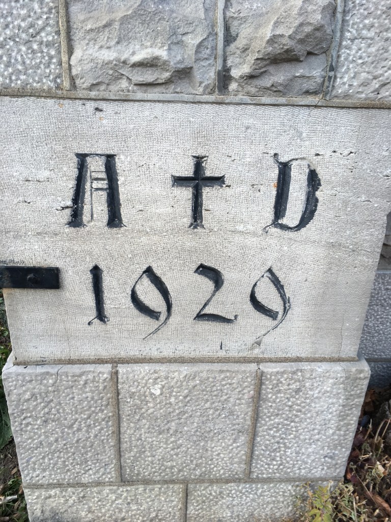
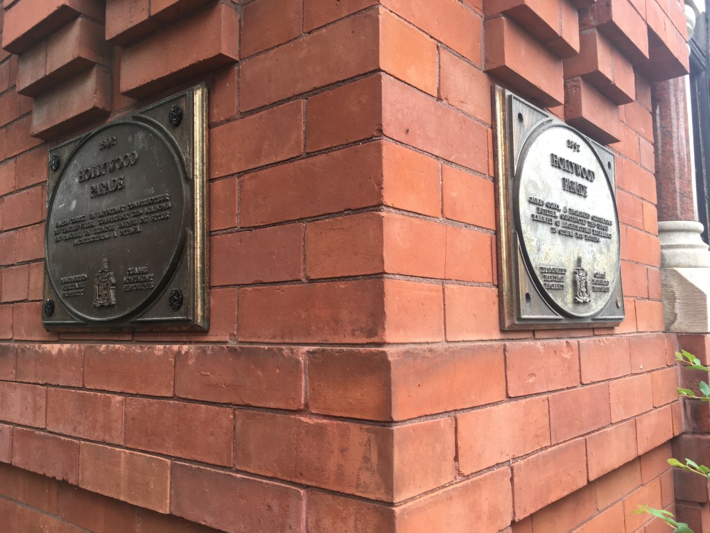
A 1874 datestone on a church that was built in 1900 is always a fun, quirky thing to find. That place has to have a story. One may assume that the datestone gives evidence that Saint Marc’s Church has been at this Elgin/Lewis street location since 1874. Saint Marc’s Church has been here in Ottawa (The Daily Citizen, February 1886), but its physical location has moved during that time. The church was founded in Ottawa in by Rev. Marc Ami in 1872 and held services at the Young Men’s Christian Association and other halls until 1885, when they built their church (The Daily Citizen, February 1886) to serve the Francophone Presbyterian community at 656 Wellington in LeBreton Flats.
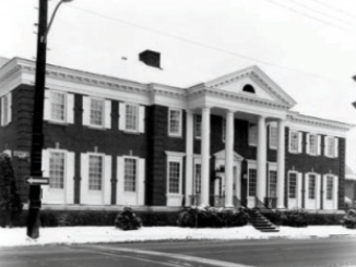
The LeBreton Flats church was destroyed in the 1901 Ottawa/Hull fire (The Ottawa Citizen, October 1964) and was rebuilt in 1902. (The Ottawa Citizen, May 1954) The new church was could seat 250 people built in the Gothic Revival style of brick and stone with a cornerstone placed on June 21, 1901, which outlined in French the destruction and rebuilding of the church. (The Ottawa Journal, June 1901)

Image – Library and Archives Canada
Insurance plan of the city of Ottawa, Ontario, Volume 1, September 1902, revised 1912, Listed on 54 of 97, sheet 49. {address 656 Wellington, Lebreton Flats}, Anglicized? French Presbyterian Church, St. Mark (St. Marc)
Rebuilding after the fire Saint Marc’s served the Francophone community in LeBreton flats for 63 more years until the land the church owned was expropriated in 1964 (The Ottawa Citizen, October 1964). Front page news of the Government expropriation of the LeBreton Flats was announced in April 1962 giving owners only 2 years notice to vacate (the Ottawa Citizen, April 1962). While it was never realized, the intention of the expropriation was to build 10 government buildings in the area, with underground parking, and recreational and park areas to beautify the area (the Ottawa Citizen, April 1962). 240 owners were affected as the government removed the “eyesore” of “industrial plants, commercial buildings and low standard housing” (the Ottawa Citizen, April 1962). The land was not developed, and in 1969 the National Capital Commission was considering a reassessment of the LeBreton lands (The Ottawa Citizen, November 1969). Now 60 years later it consists of the War Museum, an apartment complex, (The Ottawa Citizen, April 2022) and the new Ottawa Public Library and, Library and Archives complex, Adisoke.
Saint Marc’s last service at the LeBreton Flats location was held on October 4, 1964 and the congregation was made up of 100 French-speaking families from all over the Ottawa area (The Ottawa Citizen, October 1964). The organ, pulpit, communion table, and other furnishings were to be removed before demolition to be placed in the new church when it was built (The Ottawa Citizen, October 1964). Their temporary church location from October (1964 until June 1965) was at Bank and McLeod in the basement of the former McLeod Street United Church at 473 Bank Street (The Ottawa Citizen, October 1964).
Their current Elgin/Lewis street location was purchased In June 1965 (www.onland.ca, Register book 628), from the Unitarian Church of Our Father, who built their church in 1900 (The Ottawa Citizen, October 1900). Their congregation had outgrown their location and sold their building on Elgin to the Trustees of Eglise Marc, and de L’Eglise Unie du Canada for $147, 500 (www.onland.ca, Register book 628).
Currently the building is undergoing tower repairs. According to the church website Saint Marc’s “in partnership with Hare Consulting Group (an Indigenous-owned company), is set to launch a fundraising campaign to transform St. Marc’s United Church on Elgin Street (a heritage-listed building) in Ottawa in a “state of the art” restoration project. The new space will house an Aboriginal Activity Center on the lower level of the church.”